

The Oman Ophiolite: an amateur’s journal April 2017; with special thanks to
Carol Frost and Peter Keleman
Disclaimer: my geology may not be 100% accurate and will likely be edited. Also the zoomable photos are best viewed on a laptop or desktop.
Over a year ago when we were planning to hike Zion, Bryce and the Grand Canyon I was reading about the tectonic plate shifts that formed the American West Coast. Something called the “ophiolite sequence” caught my attention. Unfortunately we weren’t going to see it around any of the canyons, in fact, it exists in relatively few places on earth and the very best example is all along the north coast of Oman.
“Ophiolites are on-land exposures of igneous mantle and residual lower crust formed beneath submarine spreading ridges.” At certain tectonic plate boundaries, miles under the sea, magma pushes up and breaks through the crust forming a cleft or a ridge along the sea floor spreading the plates apart as it continually pushes up more molten matter. During this process several specific formations come into existence.
The mid-Atlantic ridge that long north/south volcanic crack along the middle of the Atlantic ocean floor that is slowly pushing the Eurasian plate and the North American plate apart is a good example. There is footage of lava emerging on the ocean floor looking like big tubes or pillows. Those lava "pillows" are the top of the ophiolite sequence. Beneath the pillow lavas (basalts) are sheeted dikes--vertical wall-like forms that harden under the pillows and spread the plates apart as more lava rises in the opening to the ridge. Beneath that are gabbro, dunite, harzburgite and peridotite. This extends down through the crust to the mantle 20-50 miles beneath the sea.
Ophiolites hardly ever come above the seafloor consequently we rarely see them. Mostly they are subducted beneath the lighter overriding plate and subsumed back into the mantle or covered over with sediment miles under the sea. Around 90 million years ago the Arabian plate pushed against the Eurasian plate. The ophiolite that had formed wasn't subducted but obducted. A 30 mile deep, 30 mile wide, 15o mile long chunk of ophiolite dislodged beneath the Tethys sea floor, flipped up and over, folded on itself, and was emplaced on top of 250 million year old Permian limestone. Then all of that sunk again beneath the sea in the Eocene 45 million years ago and was covered by more sedimentary stone mainly limestone. It was pushed up again and eventually become Oman.
Take a look at Oman in Google maps and you'll see the dark brown mountains running along the coast, that’s called the Samail Ophiolite. It starts with pillow basalts (igneous rocks formed on the seafloor that look like pillows or huge tubes), then sheeted dikes (giant perpendicular wall structures), gabbro (subterranean solidified igneous rock), then rock with various amounts of olivine and pyroxene - harzburgite (dark brown), dunite (light brown) mostly veined with magnesite (white) or another crystallized liquid and peridotite. So this massive formation that took millions of years to be formed deep under the ocean is now above ground, crumpled, folded and flipped upside down. It extends all along Oman’s north coast and inland for about 30 miles. Driving up any road into the mountains you're bound to come across some or all of these features just off the road.
ABT was performing at the Royal Opera House Muscat in early April and during some time off I took two separate trips, the first to see Permian limestone formations near Muscat and the second to Wadi Al Jizzi, about 2.5 hours from Muscat to see the ophiolite sequence. On Wednesday 4 April, I drove south from Muscat to see the Permian limestone. This limestone was fantastically deformed, folded, bent, twisted and pushed upwards in all directions.
At Speedy Oman car rental which conveniently was located in our hotel I rented a car and headed up through the ophiolite via the Muscat-Al Amerat road. There were very deep and severe road cuts along the way which gave a good look at what's inside the rock. I continued on to Al Hajar exiting there onto a gravel road and through some amazing sites. I stopped a half dozen times, hiked up through a wadi (a valley, riverbed, canyon, gulch, etc) and photographed the warped disfigured limestone. The Muscat Geological Society had placed discreet signs near some of the formations which was helpful as I had misplaced my notes for this day trip. Synclines, anticlines, concentric folds, mini-folds and a massive “eye” fold were some of the sights.


I kept hoping to bump into a geology student or eco-tourist but I saw no one. I spent several hours driving and hiking between the sights. Eventually, as I neared the coast the pavement appeared again . I followed the road out of the Permian limestone and back toward Muscat into the ophiolite. In some places Eocene limestone (45 million year old) was on top of the ophiolite and the unconformity in texture and color was striking. When I reached Mutrah, Muscat’s original seaport and marketplace I parked across from Riyam Park in a small dilapidated market area.
 The trail that goes up into the ophiolite has no marked entrance, in fact the entrance was in between two buildings in a little strip mall. I saw a few laborers having lunch in the shade between the two buildings and as I approached one of them signaled with his thumb that I was going in the right direction.
Just behind the buildings was a makeshift stone pathway. There was no vegetation just jagged stone. After climbing about 20 minutes there were some beautiful views of the sea and harbor but what was most striking was the rock all around. It was a mix of dark harzburgite and lighter dunite streaked with white veins of magnesite.
At the top of the climb there was an abandoned village that was nothing more than a few stones and a dry well. The way down included some rock-scrambling which was fun. The features of the stone changed subtly as I went down. There were several pools of water which showed rings of dissolved and dried magnesite that resembled salt rings as water evaporates.
At the bottom of the wadi was a 40 foot tall dam with no way up, over, around, or through--humm? I retraced my steps and found a way out over a ridge and down into a cemetery! At first it didn't register that it was a graveyard because it was littered with stone like everywhere else. Eventually I recognized that some of the 8" square and 12" tall stones were headstones on burial mounds. I felt as though I might be trespassing but I asked later and found out that there is nothing disrespectful about walking through a Muslim cemetery. I wound my way through an Omani neighborhood to the coast road and back around to the car. The ophiolite hike took about 2 hours but involved quite a bit of climbing and rock scrambling.


The major highways in Oman are excellent. They are well marked by destination, but they have no numbers! So highway #1 on Google maps is really “Muscat-Sohar”, there is no sign that says Highway 1 etc. There are a few 4 or 6-lane highways and the speed limit is 120 kms about 75 mph. However, out of the main part of Muscat people cross these interstates on foot, jumping over the guard rails and running across carrying their groceries. It's incredibly dangerous! Also, there are goats feeding along the side of the highways. There are quite a few police cruisers patrolling and every 4-6 miles there's a speed camera! On Saturday, my free day, I rented another car from Speedy Oman at 8am and drove straight to Sohar then turned inland on the Sohar-Al Batinah road (#7) and drove about 20 minutes up into the mountains to just passed the Al Jizzi power station. (I've learned that it may actually be a huge copper smelter but Google says it a power station!)
In a road cut on the left-hand side I could see the outline of pillow basalts. I took the next exit (Suhaylah), turned under the highway and was immediately in Wadi Al Jizzi. At this point it is several hundred meters across but there’s not much water. A creek-size stream flowed down the middle but it was easily traversed by stepping on stones. A sulfide mining road continues across the wadi and goes further up into the mountains. I stopped at this site three different times. I was facing several outcrops of exposed pillow basalts but at 10:30am they were not in direct sun so I explored it a bit then I kept on driving on the Suhaylah road which follows the course of the wadi.

I stopped on a bridge because I saw pillow basalts all along the wadi, some were fully exposed others were encased in sediment. As I drove across a bridge something off in the distance caught my eye. It turned out to be a Hawasinah formation -- more on that later. I parked on the side of the road, lept over the barrier and walked down into the wadi to inspect the pillow lavas. They look so unnatural and mysterious yet in this area they are everywhere. I had to cross over the stream several times and at this point it was somewhat more than a trickle so I had to hopscotch across on rocks and luckily didn't slip. As I was walking up the creek bed I came to the spring that feeds the stream. The wadi was completely dry above it but out of the ground flowing downstream was quite a bit of water. Had I been adventurous I would have tasted the water for its salinity and mineral content but decided to drink my bottled water instead.
I walked over to this wacky and colorful formation wondering what in the world it was. I emailed a photo to Peter Kelemen, a geologist specializing in the Oman ophiolite and he wrote back, “this looks like the Hawasinah formation, which is a rumpled rug of allochthonous, deep-water sediments that were thrust onto the Arabian continental margin beneath the ophiolite”. So, far beneath the sea under great pressure millions of years ago somewhere else these were formed then thrust up here.

I climbed back up the embankment to the car and continued on the Suhaylah road. I passed many examples of unconformity, limestone on top of ophiolite on top of limestone, etc. Eventually I got back on the highway (there were only a few cinderblock houses, perhaps abandoned, on Suhaylah road) and went back to the first pillow lava site. The sun was a little higher so I took a few more shots. About a ½ mile further down river there were two other outcrops of pillow basalt standing independently in the middle of the wadi.
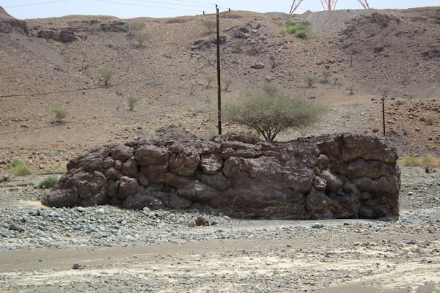
They were fascinating because of their independence from their surroundings. I hiked over and climbed up on top of one and was amused to see that the power company had stuck a telephone pole right in the middle of it. It must have taken some heavy drilling to open a hole deep enough to set a telephone pole. On the walk there I had to cross an attractive expanse of dried mud. It made for an interesting photo.

I drove southwest again just to look around the exotic landscape. After I crossed the state line I turned around and headed back to the northeast. I stopped for the last time at the pillow lava site and now the sun was shining directly on them so I took more photos and climbed up on top. I had brought to Oman my hiking shoes, “Darn Tough” socks, and leather gloves and was glad I did. A plastic bag had been blown up into a thornbush growing on top of the pillows so I carefully dislodged it (the thorns are intense) to make the site look more respectable. There was quite a bit of litter in the dry river bed. I guess it's just part of contemporary life. I saw a few lizards zooming along the rocks but no other wildlife.
I got back in the car and drove on another mining road past light yellowish fungal looking stuff growing on black cinder piles which Peter later told me was by-product of local sulfide mining. Incidentally, Peter is working on a carbon dioxide sequestration project which happens to be a property of the ophiolite. The rock can absorb CO2.
When I got back on the highway to head home there was a police checkpoint with cones set up and a big stop sign. Yikes! Luckily the police officers were either on break or had gone to the restroom because their cars were there but no policemen. I slowed down and looked around but kept on going. Whew!
When I got back on the highway to head home there was a police checkpoint with cones set up and a big stop sign. Yikes! Luckily the police officers were either on break or had gone to the restroom because their cars were there but no policemen. I slowed down and looked around but kept on going. Whew!
I filled up the gas tank in Sohar. Everybody in Oman was remarkably friendly. The guys at the gas station, and everywhere else, were very kind and helpful. The freeways here don't have overpasses at major junctions, they have roundabouts. You drive along at 75mph then occasionally you must slow down to circle a roundabout. It seems to works here.
Oman was a wonderful experience in many ways. The Omanis I met were all friendly, interesting and polite. The drivers on the highways were courteous and respectful. I always felt perfectly safe, day and night. The Royal Opera House Muscat was first class and the audiences responsive. Food, clothing and gas prices were low and the scenery amazing. I hope the company goes back, I'd love to spend more time exploring.

No comments:
Post a Comment